A sunrise drive on the Blue Ridge Parkway near Asheville asks a question most visitors answer without realizing they had a choice. Craggy Gardens sits above five thousand feet, where the ridgelines stack like theatre curtains and fog pours into valleys below with a weight you can almost feel. By mid-morning the parking area fills, car doors compete with birdsong, and the experience becomes something shared whether you intended it or not. That version of the Parkway is earned and real — nobody fakes the catch in their chest the first time the scale of the southern Appalachians lands.
But there is another morning out here, one that starts before the signed overlooks matter, where the road belongs to whoever set the alarm. An unmarked gravel pull-off. A thermos balanced on a hood. The same mountains painted by the same light, but with no one else in the frame.
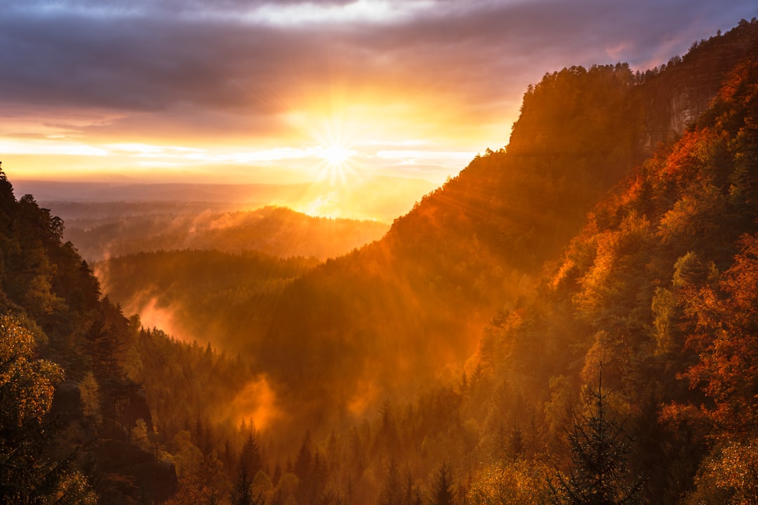
Craggy Gardens draws people for a reason. At that elevation, weather arrives sideways — clouds don't hang in the distance, they move through you. On a clear morning, you can count ridgelines deepening from green to blue to something closer to memory than color. The Craggy Pinnacle Trail climbs less than a mile from the parking area and puts you above the rhododendron balds with a view that turns in every direction. In June, those balds blush pink and purple with Catawba rhododendron. The rest of the year, what holds you is the silence and the scale.
Farther south toward Asheville, the Folk Art Center at Milepost 382 marks where most people enter the Parkway. It's not a sunrise destination — it opens at nine or ten depending on the season — but it anchors the stretch. If you're driving north from here toward Craggy Gardens, the road climbs steadily and the tree canopy closes in before the big views begin. By the time you reach the Craggies, you've earned the altitude.
The pull for these signed stops makes sense. Guardrails, interpretive plaques, parking stripes painted on asphalt — all of it signals that someone decided this view mattered enough to formalize. And they were right.
Here is the thing that shifts the whole calculation: timing.
The Parkway at 7 AM and the Parkway at 11 AM are not the same road. The speed limit hasn't changed. The overlooks haven't moved. But the light enters from the side instead of overhead, and ridgelines separate into individual planes you can almost count. Fog doesn't obscure the view — it becomes the view, filling valleys with something that looks poured rather than settled. Sound carries differently too. At sunrise the road is quiet enough to hear wind move through the balsam fir, which is a thing you will not notice at midday with a line of cars behind you.
Traffic is the other variable. The Parkway's 45 mph speed limit means a slow, shared experience on a summer afternoon. At sunrise you might have the road to yourself for miles. That changes the nature of every pull-off. The signed overlooks, the unsigned gravel shoulders, the places where the guardrail just stops and the mountain opens up — all of them become available in a way they aren't later.
South of Craggy Gardens, the Parkway descends through a stretch where the overlooks lose their signage and the views don't diminish. Tanbark Ridge Overlook sits at Milepost 376.7, lower in elevation than the Craggies but facing east with a wide panorama that catches first light cleanly. The ridge was named for a tannery that once worked the area — no plaque announces this, and most visitors drive past without slowing. At sunrise, the valley below fills with soft light before the ridgeline above you even warms, and you're standing in the shadow of the mountain watching the world brighten from the bottom up.
Near Milepost 376.6, Ox Creek Road intersects the Parkway. The gravel shoulders on either side of that intersection are where locals pull over before dawn, coffee in hand, and wait for the show. No guardrail, no painted lines, no one telling you this is the spot. The Mountains-to-Sea Trail crosses nearby, and on some mornings the only company is a through-hiker heading north.
These pull-offs don't compete with Craggy Gardens. They answer a different version of the same question: do you want the composed, elevated, everyone-should-see-this view, or the private, ground-level, you-found-this-yourself morning?
But the pattern locals follow is checking the NPS road status map the night before — and then stepping outside before dawn. If the valley below Asheville holds fog but the sky overhead is clear, that's the morning worth setting the alarm for. Fog pooling in the valleys is what creates the layered ridgeline views from Craggy Gardens. If the ridgeline itself is socked in, the lower pull-offs near Tanbark Ridge often sit below the cloud line and become the better play.
Access: Four primary Asheville entrances:
Milepost 382.6 — US Highway 70 (Folk Art Center area)
Milepost 384.7 — US 74A (best from I-40 east)
Milepost 388.8 — US 25 (Biltmore area)
Milepost 393.6 — NC 191 (nearest from I-26, NC Arboretum)
The Parkway section from Asheville (MP 382) north to Craggy Gardens (MP 364) reopened in September 2025 after Hurricane Helene repairs.
Confirm current road status at nps.gov/blri before any visit — conditions change and additional closures may occur.
Craggy Gardens: Milepost 364. Visitor center and Craggy Pinnacle Trail accessible.
Craggy Gardens Picnic Area was closed as of Sept 2025 — confirm current status.
Elevation above 5,000 feet means temperatures run noticeably cooler than Asheville, and ice closures are common on winter mornings before 9 AM. If the gate is down, it's down for a reason.
Tanbark Ridge Overlook: Milepost 376.7. Roadside pull-off, east-facing. No facilities.
Ox Creek Road pull-offs: Near Milepost 376.6 where Ox Creek Road intersects the Parkway. Gravel shoulders, no marked parking. Ox Creek Road itself winds down into the Weaverville area.
Folk Art Center: Milepost 382. Open daily typically 9 or 10 AM to 5 or 6 PM depending on season (verify before planning)
Free admission. Useful as an orientation point, not a sunrise stop.
Winter and weather: Higher elevation sections close for ice and snow, sometimes without warning. Check the NPS road closure map the morning of your drive. If the road is open but fog sits on the ridgeline, the lower overlooks between MP 375–380 often sit below the cloud line.
Webcams exist on the Parkway:
The Blue Ridge Parkway Foundation runs webcams at The Bluffs Restaurant (MP 241),
Blue Ridge Music Center (MP 213), and Pisgah Inn (MP 408).
None of those cover the Craggy Gardens / Tanbark Ridge stretch (MP 364–382).
The NPS road status page: nps.gov/blri/planyourvisit/roadclosures.htm — this is what locals actually check for closures, especially winter ice gates.
No fuel or food on the Parkway. Fill up in Asheville before heading north.
Two versions of the same morning. One framed by guardrails and earned by elevation — the kind of view that makes you understand why someone built a road here. The other found by arriving before the road remembers it's a destination, where the pull-off has no name and the view belongs to whoever showed up. The Parkway doesn't care which version you choose. It just asks whether you set the alarm.
Want to feature your business on the DirectStay Blog?
Want to feature your business on the DirectStay Blog?

Connect with travelers, share your space, and join a community of hosts earning together.